
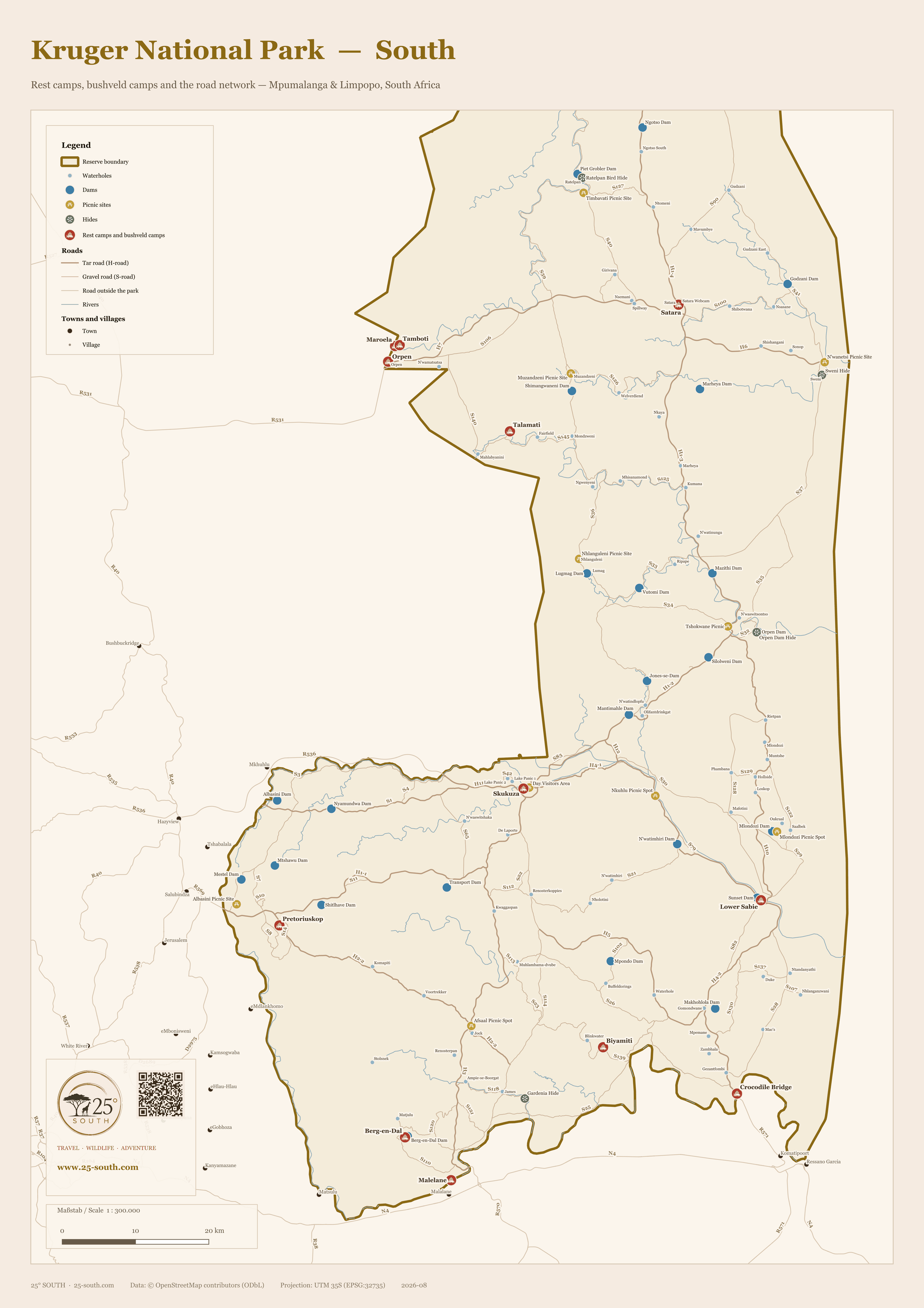
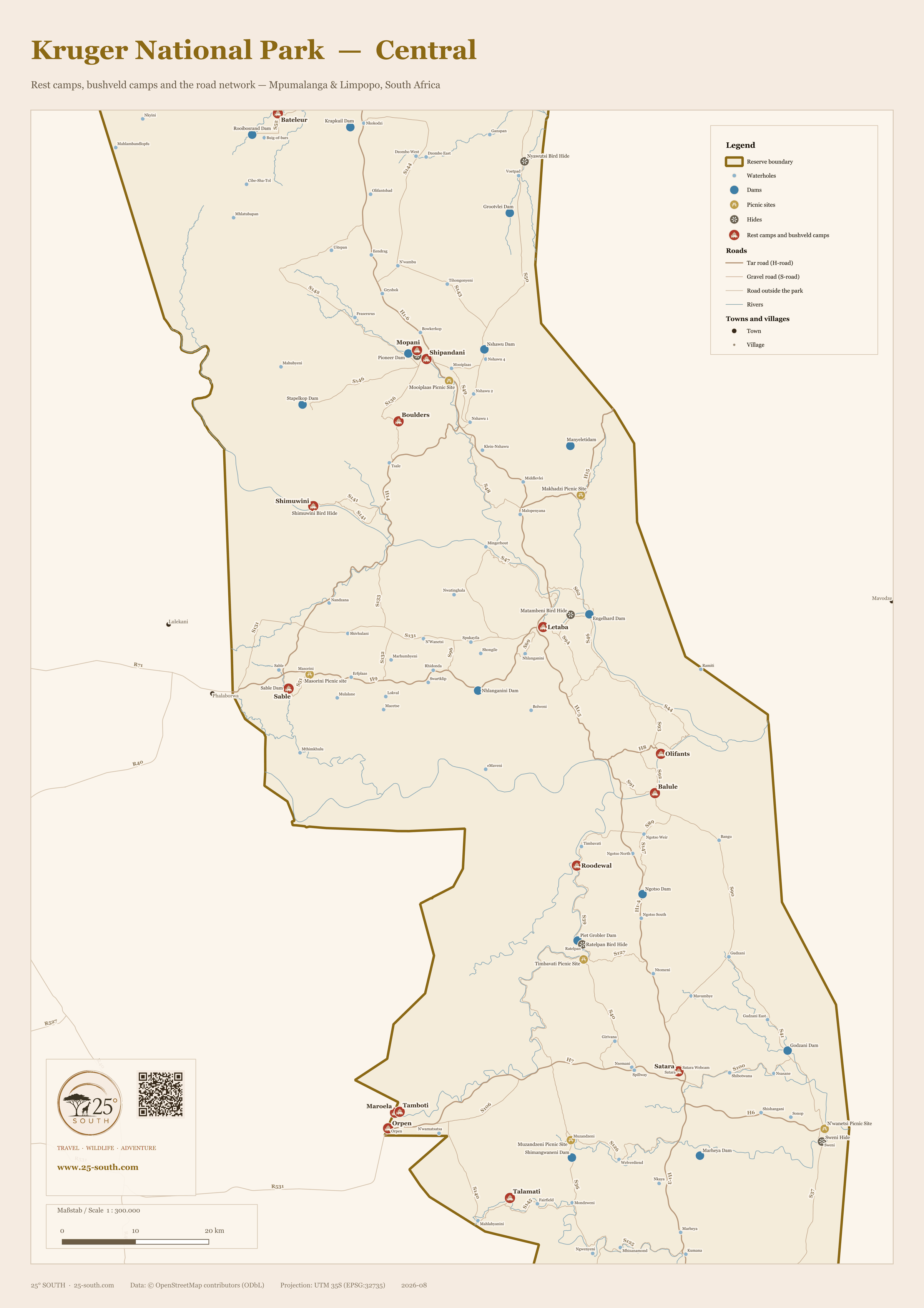
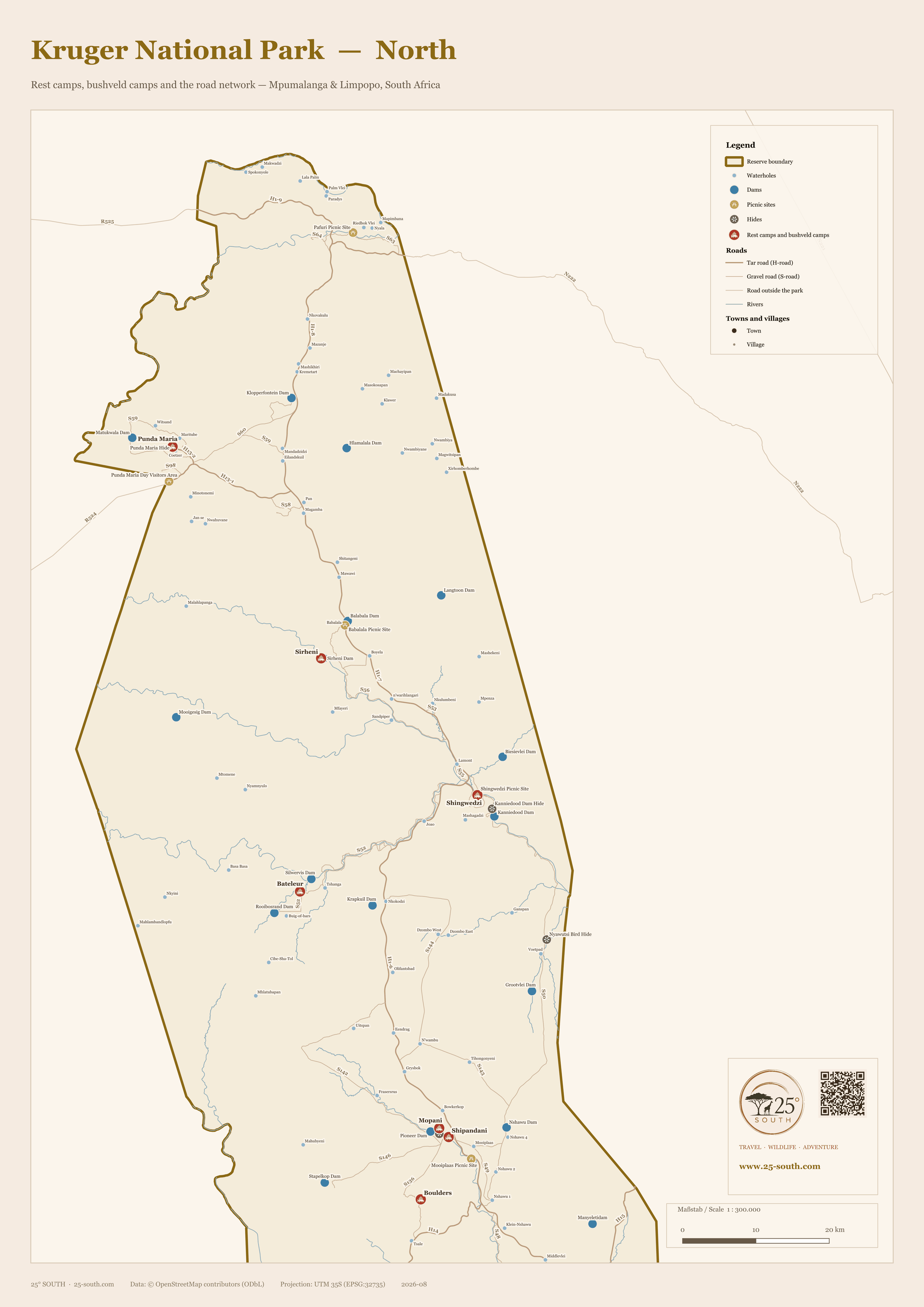
Kruger runs 350 kilometres from the Crocodile River to the Limpopo, and that shape is the reason almost every map of it is either too small to read or too big to print. So this is three sheets rather than one, all drawn to the same scale — 1:300,000, roughly a centimetre to three kilometres — and each one overlaps its neighbour by about thirty kilometres, so nothing falls down the join. Satara and Orpen appear on both the south and the central sheet; Mopani, Shipandani and Boulders on both the central and the north.
Each sheet carries all 25 SANParks camps, the numbered H and S roads, the rivers, and the dams, waterholes, picnic sites and hides that are worth planning a morning around. Roads and settlements outside the park are shown too, because that is where most people are coming from. Click any sheet to open it full size.
Part of the 25° South map series — original reference maps of Africa’s safari regions, free to use with attribution.
South — Malelane to Orpen
Skukuza, Lower Sabie, Berg-en-Dal, Pretoriuskop, Crocodile Bridge, Biyamiti, Malelane, Talamati, Maroela, Tamboti, Orpen and Satara. The busiest third of the park, and the one most first-time visitors never leave.

Central — Orpen to Bateleur
Letaba, Olifants, Balule, Mopani, Shipandani, Boulders, Shimuwini, Sable, Bateleur and Roodewal, with Satara, Orpen and the Timbavati camps repeated from the south sheet. Most of Kruger’s bushveld camps sit in this band.

North — Mopani to the Limpopo
Punda Maria, Sirheni, Shingwedzi and Bateleur, with Mopani, Shipandani and Boulders repeated from the central sheet. Thin on camps, long on distance — which is exactly why it repays planning.

Reading the map
Camps carry a red bed symbol and their name — rest camps, satellite camps, bushveld camps and the two overnight hides are all marked the same way, because on the ground the difference is what you book, not where you go. What each one is actually like, and what it costs, is on the Where to Stay page, where all 25 are compared side by side.
Roads follow Kruger’s own convention: the darker lines are the tar H-roads, the lighter ones the gravel S-roads, and both carry their numbers. Blue discs are dams, the smaller pale dots waterholes and pans — there are more than 170 of them on these sheets, and they are the reason a slow S-road often beats a fast H-road. Yellow marks a picnic site, where you may get out of your car; green marks a hide.
All three sheets are north-up. The scale bar sits inside the map frame, in whichever corner the park leaves empty.
Using this map
This map is free to use — on a website, in a print piece, in a presentation — as long as you credit 25° South and link back to this page. That is the whole licence (CC BY 4.0). You do not need to ask us first.
Credit line — copy and paste
Plain text
Map by 25° South (25-south.com), CC BY 4.0
HTML
Map by <a href=”https://25-south.com/destinations/south-africa/kruger-national-park/map/”>25° South</a>, CC BY 4.0
Print versions exist at A2 (594 × 420 mm, 300 dpi) for all three sheets. Ask and we will send them.
Notes on accuracy
Everything here is drawn from OpenStreetMap, which in Kruger is unusually good — the road network is mapped by people who drive it. Camp positions were checked one by one against SANParks’ own listings. The water is where the honest caveat sits: dams and waterholes are mapped as they are named in the open data, so a few carry a local name rather than the one on the SANParks signboard, and a handful of seasonal pans are shown that will be dry for much of the year.
The private reserves along the western boundary are deliberately not drawn here — they have a map of their own. The Mozambican half of the Great Limpopo Transfrontier Park is likewise left for a separate sheet.
Spotted something wrong? Roads close, camps change and open data has gaps — tell us and we will correct it.