
Part of the 25° South map series — original reference maps of Africa’s safari regions, free to use with attribution.
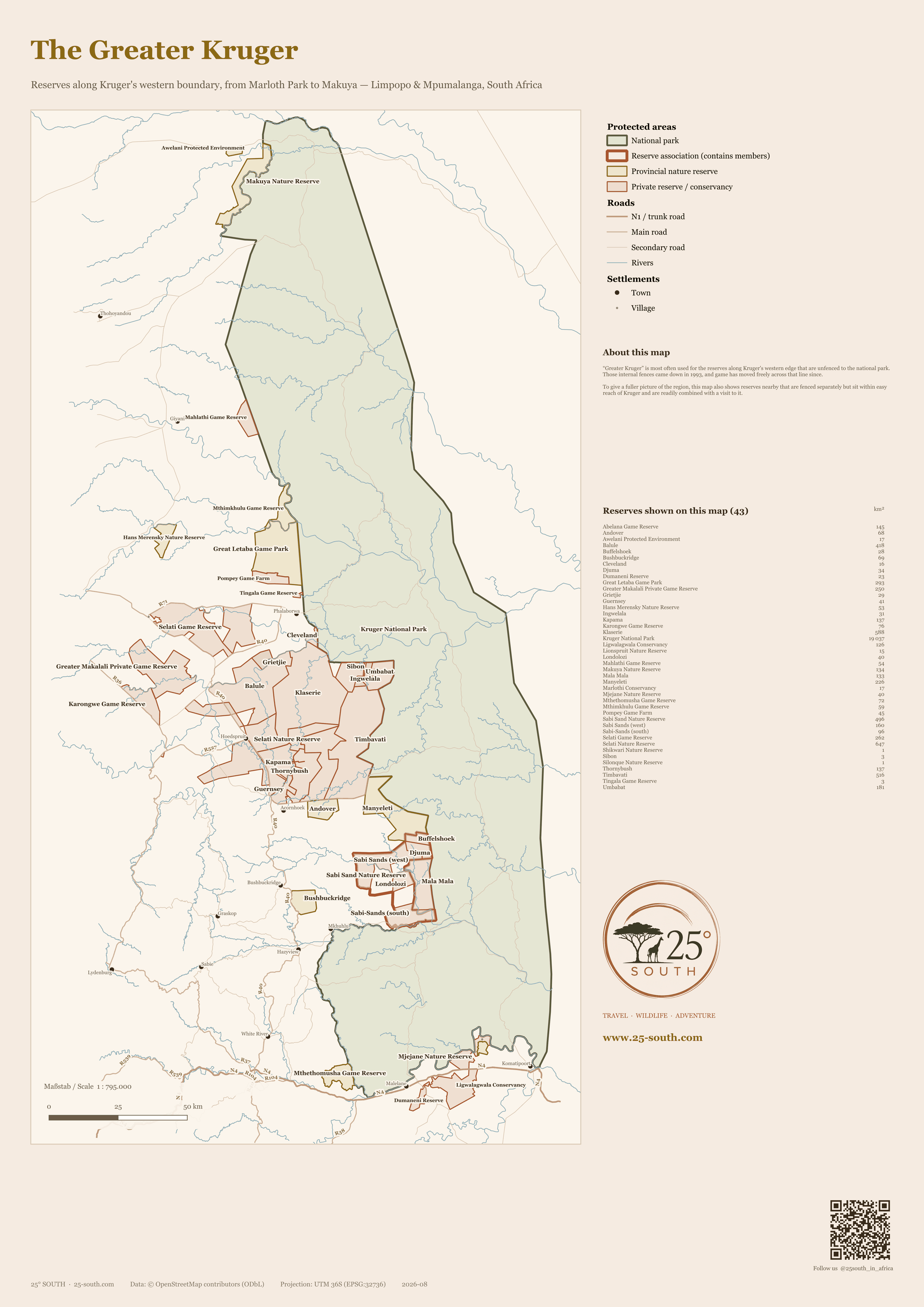
“Greater Kruger” is most often used for the reserves along Kruger’s western edge that are unfenced to the national park. Those internal fences came down in 1993, and game has moved freely across that line since. It is a belt that runs almost 400 kilometres, from Marloth Park on the Crocodile River in the south to Makuya in the far north — far larger than the handful of well-known names suggests, and almost never mapped end to end. This map shows all 43 protected areas we could source boundaries for, drawn to the same scale.
A few reserves on the map are fenced separately from Kruger rather than open to it — Greater Makalali, Karongwe, Selati and Hans Merensky among them. They are included because they sit within easy reach and are readily combined with a Kruger visit, which is how most people actually travel here.
Reserves shown on this map
43 protected areas, alphabetical. Areas are measured from the mapped boundary and rounded to the nearest square kilometre.
| Name | Type | Area km² |
|---|---|---|
| Abelana Game Reserve | Private reserve / conservancy | 145 |
| Andover | Provincial nature reserve | 68 |
| Awelani Protected Environment | Provincial nature reserve | 17 |
| Balule | Private reserve / conservancy | 418 |
| Buffelshoek | Private reserve / conservancy | 28 |
| Bushbuckridge | Provincial nature reserve | 69 |
| Cleveland | Private reserve / conservancy | 16 |
| Djuma | Private reserve / conservancy | 34 |
| Dumaneni Reserve | Private reserve / conservancy | 23 |
| Great Letaba Game Park | Provincial nature reserve | 293 |
| Greater Makalali Private Game Reserve | Private reserve / conservancy | 250 |
| Grietjie | Private reserve / conservancy | 29 |
| Guernsey | Private reserve / conservancy | 41 |
| Hans Merensky Nature Reserve | Provincial nature reserve | 53 |
| Ingwelala | Private reserve / conservancy | 31 |
| Kapama | Private reserve / conservancy | 137 |
| Karongwe Game Reserve | Private reserve / conservancy | 76 |
| Klaserie | Private reserve / conservancy | 588 |
| Kruger National Park | National park | 19 037 |
| Ligwalagwala Conservancy | Private reserve / conservancy | 126 |
| Lionspruit Nature Reserve | Provincial nature reserve | 15 |
| Londolozi | Private reserve / conservancy | 40 |
| Mahlathi Game Reserve | Private reserve / conservancy | 54 |
| Makuya Nature Reserve | Provincial nature reserve | 134 |
| Mala Mala | Private reserve / conservancy | 133 |
| Manyeleti | Provincial nature reserve | 226 |
| Marlothi Conservancy | Private reserve / conservancy | 17 |
| Mjejane Nature Reserve | Private reserve / conservancy | 40 |
| Mthethomusha Game Reserve | Provincial nature reserve | 72 |
| Mthimkhulu Game Reserve | Provincial nature reserve | 59 |
| Pompey Game Farm | Private reserve / conservancy | 45 |
| Sabi Sand Nature Reserve | Reserve association | 496 |
| Sabi Sands (west) | Private reserve / conservancy | 160 |
| Sabi-Sands (south) | Private reserve / conservancy | 96 |
| Selati Game Reserve | Private reserve / conservancy | 262 |
| Selati Nature Reserve | Private reserve / conservancy | 647 |
| Shikwari Nature Reserve | Private reserve / conservancy | 1 |
| Sibon | Private reserve / conservancy | 3 |
| Silonque Nature Reserve | Private reserve / conservancy | 1 |
| Thornybush | Private reserve / conservancy | 137 |
| Timbavati | Private reserve / conservancy | 516 |
| Tingala Game Reserve | Private reserve / conservancy | 3 |
| Umbabat | Private reserve / conservancy | 181 |
Using this map
This map is free to use — on a website, in a print piece, in a presentation — as long as you credit 25° South and link back to this page. That is the whole licence (CC BY 4.0). You do not need to ask us first.
Credit line — copy and paste
Plain text
Map by 25° South (25-south.com), CC BY 4.0
HTML
Map by <a href=”https://25-south.com/destinations/south-africa/greater-kruger/map/”>25° South</a>, CC BY 4.0
Notes on accuracy
Every reserve area was cross-checked against the operator’s or the province’s own published figure. Two are worth a caveat: Great Letaba Game Park maps at 293 km² against a published figure nearer 420, and the Sabi Sand outline totals 496 km² against a commonly quoted 650. Both gaps are in the open data rather than in the drawing, and we have left them as they are rather than guess.
The Drakensberg escarpment reserves west of the belt — Blyde River Canyon, Mac-Mac, Mount Sheba and their neighbours — are not included. They are a different landscape and do not share Kruger’s boundary. The Mozambican and Zimbabwean halves of the Great Limpopo Transfrontier Park are likewise left for a map of their own.
Spotted something wrong? Reserve boundaries change and open data has gaps — tell us and we will correct it.