
Part of the 25° South map series — original reference maps of Africa’s safari regions, free to use with attribution.
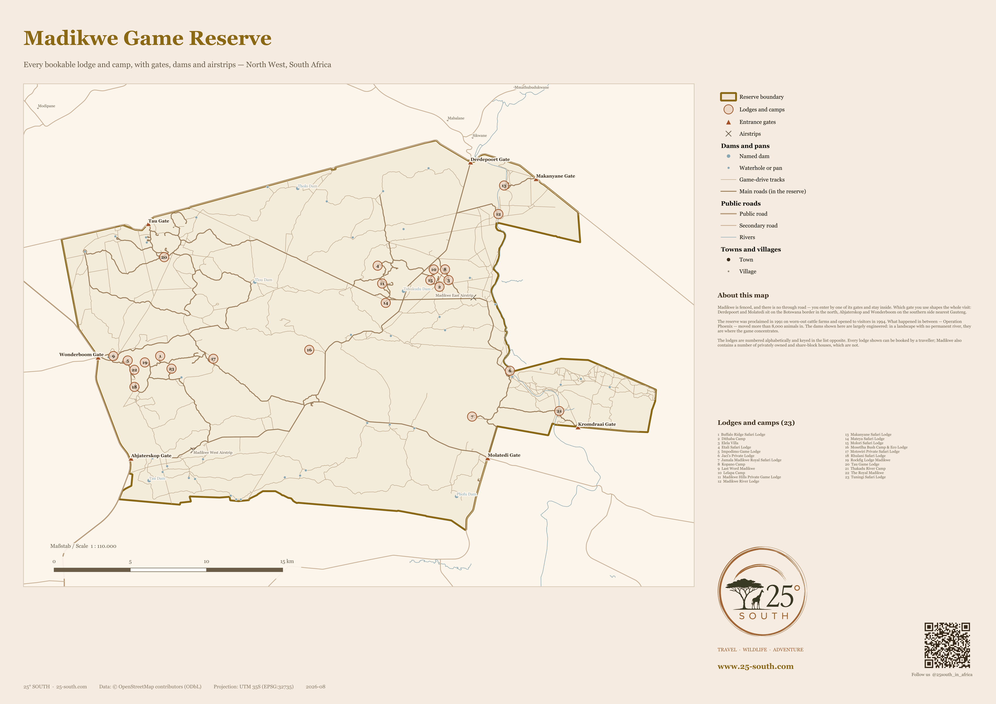
Madikwe is fenced, and there is no through road. You enter by one of seven gates and stay inside — which makes it one of the few reserves where knowing the layout before you arrive genuinely changes the trip. Which gate you use, and where your lodge sits in relation to it, decides how much of your first and last day is spent driving.
Every lodge on this map can be booked by a traveller. They are numbered alphabetically and keyed in the table below. Madikwe also contains a number of privately owned and share-block houses; those are not shown, because you cannot stay in them.
The reserve was proclaimed in 1991 on worn-out cattle farms and opened to visitors in 1994. What happened in between — Operation Phoenix — moved more than 8,000 animals of 28 species in. The dams shown here are largely engineered: in a landscape with no permanent river, they are where the game concentrates, and they are the reason the game-drive network runs where it does.
Lodges and camps shown on this map
All 23 bookable lodges and camps, numbered alphabetically to match the map. Where several sit within a few hundred metres of each other, the numbers are fanned out with a fine line back to the true position.
| # | Lodge or camp |
|---|---|
| 1 | Buffalo Ridge Safari Lodge |
| 2 | Dithaba Camp |
| 3 | Elela Villa |
| 4 | Etali Safari Lodge |
| 5 | Impodimo Game Lodge |
| 6 | Jaci’s Private Lodge |
| 7 | Jamala Madikwe Royal Safari Lodge |
| 8 | Kopano Camp |
| 9 | Last Word Madikwe |
| 10 | Lelapa Camp |
| 11 | Madikwe Hills Private Game Lodge |
| 12 | Madikwe River Lodge |
| 13 | Makanyane Safari Lodge |
| 14 | Mateya Safari Lodge |
| 15 | Molori Safari Lodge |
| 16 | Mosetlha Bush Camp & Eco Lodge |
| 17 | Motswiri Private Safari Lodge |
| 18 | Rhulani Safari Lodge |
| 19 | Rockfig Lodge Madikwe |
| 20 | Tau Game Lodge |
| 21 | Thakadu River Camp |
| 22 | The Royal Madikwe |
| 23 | Tuningi Safari Lodge |
Read more about several of these on the Where to Stay page.
The seven gates
Abjaterskop and Wonderboom are on the southern side, closest to Gauteng and the usual self-drive approach. Derdepoort and Molatedi sit on the Botswana border in the north. Kromdraai is on the eastern side, Makanyane in the north-east, and Tau on the western boundary. Lodges will tell you which gate to use; the difference between the right one and the wrong one can be an hour.
Using this map
This map is free to use — on a website, in a print piece, in a presentation — as long as you credit 25° South and link back to this page. That is the whole licence (CC BY 4.0). You do not need to ask us first.
Credit line — copy and paste
Plain text
Map by 25° South (25-south.com), CC BY 4.0
HTML
Map by <a href=”https://25-south.com/destinations/south-africa/madikwe/map/”>25° South</a>, CC BY 4.0
Notes on accuracy
One figure is worth flagging. The mapped boundary encloses 618 km² against a commonly published 750 km². The difference is almost certainly the privately owned land incorporated into the reserve over time, which the open boundary data does not yet reflect. We have drawn what the data says rather than adjusting a boundary to match a published figure.
Where lodges sit within a few hundred metres of each other — the four camps of Madikwe Safari Lodge, for instance — the numbers are fanned out around their true centre and joined to it by a fine line, so nothing is hidden and nothing is silently moved. The road network is shown for orientation, not for route planning — driving in Madikwe is with a guide.
Spotted something wrong? Lodges open, close and change hands, and open data has gaps — tell us and we will correct it.